
Frequently Asked Questions…
What is your service area?
Our primary service area includes: Wilkes, Iredell, Alexander, Catawba, Caldwell, Burke, Avery, Watauga, Ashe, Alleghany, Surry and Yadkin counties. Other areas available upon request.
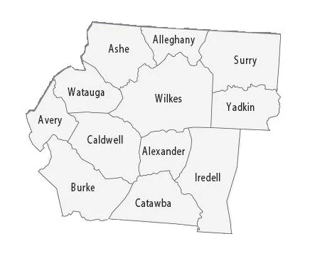
Primary Service Area
What are the steps to a typical survey?
Work is started on your survey project before you see the crew at the site. The first step is to perform deed research to determine the description in the title to the property and the adjoining properties. A deed plot map is prepared, similar to a tax map. The next step is the field survey. If corners are missing, a return to the office may be necessary to do some calculations before returning to set the missing corners. The last step is drawing the final map and presenting it to the client.
Should I obtain a survey before I purchase a home?
Yes. A home is likely the biggest investment of your life, and only a Professional Land Surveyor can determine the boundaries of the property. By having your property surveyed before you buy, you will know where all the property lines are, what you are buying, and whether any issues exist with the property boundaries.
Should I obtain a survey before building an addition to my home, installing a fence, landscaping, or making other improvements to my property?
Yes. By having a survey done first, you can plan your project and make sure it is within the boundaries of your land. When a homeowner builds an addition or new building, a Land Surveyor can locate all the features of the property that help determine the building setback and the size of addition or new structure allowed. Fences that encroach onto a neighbor’s property have the potential to turn good neighbors into bad neighbors.
Do I need a survey to get flood insurance?
Yes. The exact location of a flood hazard area in relation to your property can only be determined by a Land Surveyor. A FEMA Elevation Certificate is used to determine what a homeowner must pay for flood insurance or confirm the property is outside of the Flood Hazard Area.
Why would someone need a topographic survey?
A topographic survey is a survey of the elevation of the ground surface. Topographic surveys are typically used by designers when preparing construction plans.
Is a deposit required?
Yes; anon-refundable deposit is required to begin work.
When is final payment due?
Final payment is due upon completion of the work. Payment is not contingent on third parties, real estate closings, etc.
What is the difference between recording a map and recording a deed?
A map shows where property boundaries are located, or proposed. A map does not transfer title to property. A deed transfers the title to the property. A proposed easement shown on a map is not valid until the easement (deed) document is recorded.
When do I need a new legal description?
A legal description is the description used in a deed to describe the property you are buying or selling. If you are having property surveyed that you already own then you do not need a legal description unless you are planning to sell the property and use the updated description. If you are buying property, you will need a legal description to describe the property you are buying. For example the current legal description may describe corners as trees no longer present, or include names of former owners of adjoining lands. An updated legal description would describe the same property but with more precise, updated information.
When do I need a metes and bounds description?
A metes and bounds description is a type of legal description used to describe a property boundary by listing the bearings and distances of each line. This the most common type of legal description that is used to record the location of boundary lines when a map is not recorded. If a map is recorded describing the subject property, a metes and bounds description is not necessary. The legal description would just reference the recorded map.
Should I record the map to my property?
In most cases; Yes. Recording the map makes it available to the public for everyone to see. In most every case, this is better for the landowner, buyer, seller, and adjoining owners. As the old saying goes, “A picture is worth a thousand words.” There are certain requirements for recording a map. If you plan on recording your map you need to make the surveyor aware before the map is issued so that he/she can provide the map in recordable form.
What is the process to record a map?
Each County has varying Register of Deeds requirements. We can typically e-record a map without delay if it is a survey of an “existing” parcel of land with no changes to the boundary line. The map is immediately available on-line through the Register of Deeds website. There are three additional requirements to record a map of a “proposed” parcel of land such as a new lot, a change to an existing lot, a subdivision, etc. The additional requirements prior to presenting to the Register of Deeds are generally as follows: (1) the map must be signed by the current owner(s) of the property; (2) the changes must be approved by the planning department having jurisdiction; (3) the map must be signed by a County Review Officer.
Can SurveyPros e-record my plat?
Yes; if the Register of Deeds accepts plats for e-recording. The e-filing fee is typically $50 - $150.